 |
|
|
|
|
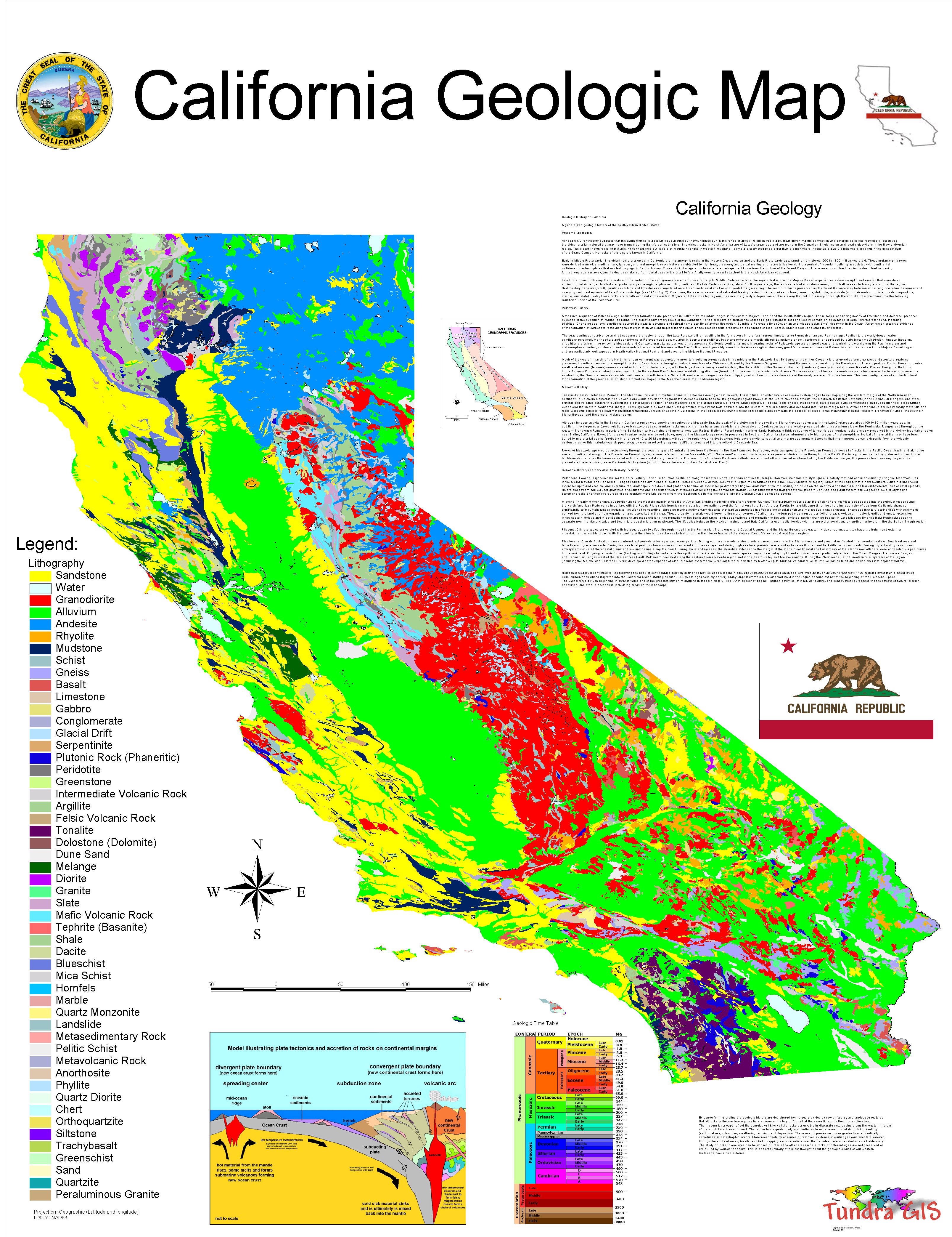
| Map Gallery Slide Show | Image 42A of 75 | California Geology Map |
 |
||
| What is a Geologic Map? | ||
A geologic map shows the distribution, relationship, and composition of earth materials such as rocks and surficial deposits (landslides, sediments) and shows structural features of the earth (faults, folded strata). Special purpose maps or derivative maps may only show details of faulting, landsliding, mineralization or other geologic processes or features. A geologist compiles the data to be presented on a map through the use of field observations, aerial photographs, remote sensing information, topographic information, soil survey information, and laboratory analyses. The geologic data, in layer fashion, are typically printed upon a base map. The base map may show the topography, roads, rivers, or other cultural or natural features in the map area. Modern maps are in digital form, extending their usefulness in decision-making by allowing geologic information to be combined with other data, such as demographics or infrastructure. Explanatory text on the maps provides information on the geologic age of the materials as well as their physical properties. A segment of a typical geologic map is shown above. On the map the geologist has recorded the locations, types, and ages of the rock units and surficial materials by using various standard colors, symbols and patterns overlain on a topographic base map. The basic rock units shown on the map are called formations. For example on the map the green area labeled "Kp" shows the areal extent of the Panoche Formation of Cretaceous age. Similarly, the portion of the map labeled "Mvqa" represents in map view the areal extent of an unnamed formation composed of a volcanic rock called andesite of Miocene age. A formation is usually named after a geographic feature (mountain, canyon, or town) near the area where the unit was first identified. The geologically most recent deposits on the map are the landslides ("Qls") depicted in yellow with arrows showing the direction of movement or "flow". Using special symbols, the geologist has recorded other significant observations on the map such as faults (bold black lines), folds, contacts between rock units, and the strike and dip of formations (respectively, the direction of a horizontal line within a unit and the angle that the unit slopes in outcrop). The explanatory text for the geologic map above is not shown. For more information about geologic maps see the "Related Links About Geologic Maps" below. Use of Geologic Maps A geologic map is the principal tool of a geologist or engineer who either needs to convey or decipher information about the Earth’s surface. Geologic maps are used to interpret the structure, stratigraphy, mineralogy, paleontology, and the historical record of the Earth’s crust. Geologic maps are used to locate energy resources (such as petroleum, natural gas, coal, and geothermal resources). They are used to locate sources of groundwater and mineral deposits (such as gold, iron, copper, clay and construction aggregate). Geologic maps are also used to identify areas that may contain potential mineral hazards, such as mercury, asbestos, or radon. Geologic maps are used to identify potential geologic hazards such as landslides, earthquake fault zones, areas susceptible to liquifaction, historic flood zones, volcanoes and areas susceptible to tsunamis. Geologic maps are used by land-use planners to identify and determine which areas are suitable for agriculture and urban development. They are a fundamental resource for environmental and engineering applications. Geologic maps provide an enormous amount of information needed to understand the Earth and to understand the geology of other planets by comparison. Value of Geologic Maps The value of geologic maps is illustrated by the direct economic gain from the discoveries of energy resource deposits (coal, natural gas, oil, or geothermal sources), industrial mineral resource deposits (iron-ore, copper, construction aggregate, limestone, borates, or rare-earth deposits), and precious mineral resource deposits (gold, silver, or gemstones). Indirect socioeconomic value is gained through the use of geologic maps for making wise land-use planning and safe engineering decisions. Such decisions are based on avoidance of natural hazards, optimizing site conditions for construction projects, and conserving natural resources. |
||
| CLICK HERE TO DOWNLOAD | ||
| < back | up ^ | next > |