 |
|
|
|
|
| Map Gallery Slide Show | Image 48 of 75 | Hampton Roads Tsunami Inundation |
|
Hampton Roads Tsunami Inundation (Requires Adobe Flash Player Installed) 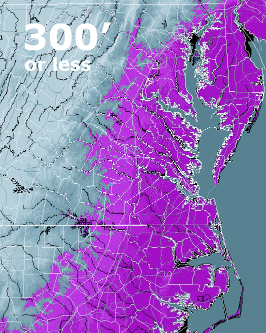 |
||
|
So here’s the question… “IF” a 300 foot
tsunami reached the East Coast, how far inland would it go? The short answer, and one that many may think to be accurate, is that it will go inland until the elevation of the land is higher than the tsunami. While that sounds logical, there are variables… Actually, the distance a tsunami will travel inland has more to do with the energy it still has left as it hits the shore. A tsunami will speed across the ocean at hundreds of miles an hour but at a relatively small height (because the ocean is DEEP). Its speed decreases as it approaches the shoreline (because the ground beneath it is getting shallower) but its energy begins to transfer to its monstrous HEIGHT. When the speed of the wave approaches zero, the wave breaks, much of its energy is released and it will not go too much further. A tsunami that reaches a height of 300 feet when it rears up at the shore, will lose energy as it travels inland. It’s all about energy. Frequency (depending on the source of the tsunami?) and Amplitude (shape of ocean floor, shoreline and up-slope factors). It is conceivable that some tsunamis will rear up quickly (and very high) once they reach the shore (depending on the shape of the ocean floor leading to the shore), and then ‘break’ and lose much of its energy in a relatively short distance, while another tsunami may be more compressed (in frequency) and be thrust forward very quickly while traveling a long distance inland (remember Japan?). There are scientifically sound reasons for concern that at some point a mega-tsunami could engulf the entire East Coast with a wave almost 300 feet high sweeping everything and everybody up to 20 miles inland. The consequences of such a relatively unlikely (but very possible) event in loss of life and property are beyond the realm of imagination. Out of curiosity and an interest in maps, I have custom built the following elevation maps based on high resolution data from USGS digital elevation maps of the United States, particularly the East Coast. I have modeled several layers of elevation of the East Coast to illustrate various height scenarios of tsunami versus geography as it travels inland. Having said that, there are many variables and factors as to how far a tsunami would travel inland, so just because a section of coastal geography doesn’t reach the height of 300 feet for say, 50 miles, doesn’t mean that the tsunami will have enough energy to travel fifty miles. There are some instances where such a tsunami would probably only travel several miles while there are other scenarios where it may roar up a river way or bay and devastate far inland (e.g. 30 miles up Delaware Bay to Dover, another 30 to Wilmington and then 20 more to Philadelphia as it builds enormous height up the waterway). Regardless of the factors, I felt that you may be curious to see following elevation graphics that I layered together which increment 75 feet all the way to 300 feet in height along the U.S. East Coast. I would guesstimate that if you live within 20 miles of the coast, you may be vulnerable to a Canary Island ‘event’. Fortunately, these don’t happen very often… Several observations regarding a 300 foot tsunami would be the probable devastation of the following major East Coast cities… Portland, ME (~ 50′) Boston, MA (~ 30′) New Haven, CT (~ 50′) Bridgeport, CT (~ 40′) New York City, NY (~ 20′) Jersey City, NJ (~ 30′) Newark, NJ (~ 50′) Atlantic City, NJ (~ 10′) Wilmington, DE (~ 80′) Philadelphia, PA (~ 40′) Virginia Beach, VA (~ 10′) Wilmington, NC (~ 20′) Myrtle Beach, SC (~ 20′) Charleston, SC (~ 10′) Savannah, GA (~ 10′) Daytona Beach, FL (less than 10′) West Palm Beach, FL (less than 10′) Fort Lauderdale, FL (less than 10′) Miami, FL (less than 10′) There are countless cities in between these coastal cities. The Eastern Seaboard of the United States includes some of the largest metropolitan areas in the country. Over one third of the country (more than 100 million people) live along the East Coast. Evacuation would be virtually impossible for most (except for the astute who act quickly) due to only hours notice, probable doubt, and the subsequent immediate gridlock that would follow. |
||
| The maps below simply show elevation… not the expected distance a 300 foot tsunami would travel. | ||
| CLICK HERE TO DOWNLOAD | ||
| < back | up ^ | next > |