 |
|
|
|
|
| Map Gallery Slide Show | Image 49 of 75 | Saratoga Topography |
 |
||
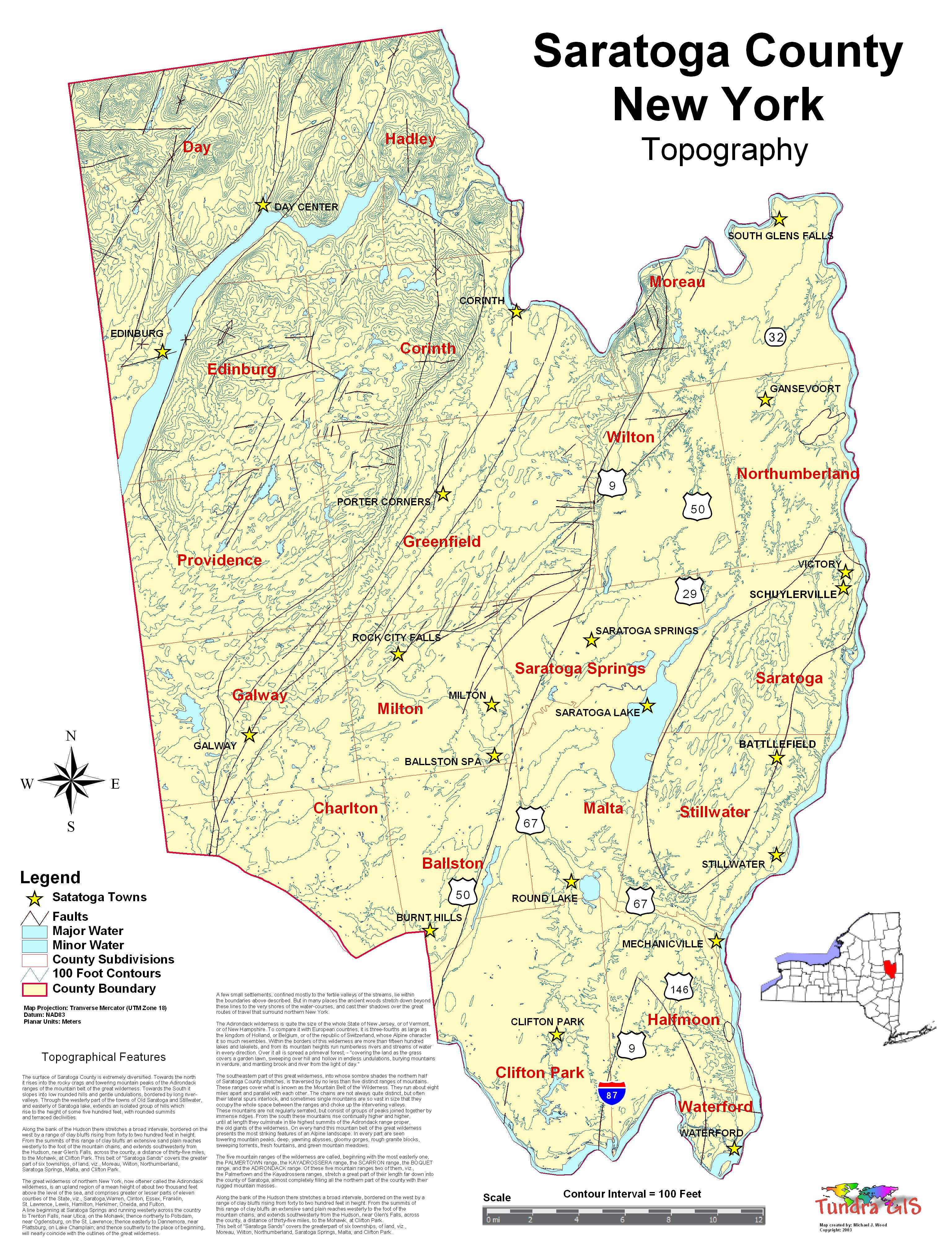
| Saratoga County New York Topographic
Map The surface of Saratoga County is extremely diversified. Towards the north it rises into the rocky crags and towering mountain peaks of the Adirondack ranges of the mountain belt of the great wilderness. Towards the South it slopes into low rounded hills and gentle undulations, bordered by long river-valleys. Through the westerly part of the towns of Old Saratoga and Stillwater, and easterly of Saratoga lake, extends an isolated group of hills which rise to the height of some five hundred feet, with rounded summits and terraced declivities. The great wilderness of northern New York, now oftener called the Adirondack wilderness, is an upland region of a mean height of about two thousand feet above the level of the sea, and comprises greater or lesser parts of eleven counties of the State, viz. Saratoga,Warren, Clinton, Essex, Franklin, St. Lawrence, Lewis, ,Hamilton, Herkimer, Oneida, and Fulton. A line beginning at Saratoga Springs and running westerly across the country to Trenton Falls, near Utica, on the Mohawk; thence northerly to Potsdam, near Ogdensburg, on the St. Lawrence; thence easterly to Dannemora, near Plattsburg, on Lake Champlain; and thence southerly to the place of beginning, will nearly coincide with the outlines of the great wilderness. A few small settlements, confined mostly to the fertile valleys of the streams, lie within the boundaries above described. But in many places the ancient woods stretch down beyond these lines to the very shores of the water-courses, and cast their shadows over the great routes of travel that surround northern New York. The Adirondack wilderness is quite the size of the whole State of New Jersey, or of Vermont, or of New Hampshire. To compare it with European countries, it is three-fourths as large as the kingdom of Holland, or Belgium, or of the republic of Switzerland, whose Alpine character it so much resembles. Within the borders of this wilderness are more than fifteen hundred lakes and lakelets, and from its mountain heights run numberless rivers and streams of water in every direction. Over it all is spread a primeval forest, - "covering the land as the grass covers a garden lawn, sweeping over hill and hollow in endless undulations, burying mountains in verdure, and mantling brook and river from the light of day." The southeastern part of this great wilderness, into whose sombre shades the northern half of Saratoga County stretches, is traversed by no less than five distinct ranges of mountains. These ranges cover what is known as the Mountain Belt of the Wilderness. They run about eight miles apart and parallel with each other. The chains are not always quite distinct, but often their lateral spurs interlock, and sometimes single mountains are so vast in size that they occupy the whole space between the ranges and choke up the intervening valleys. These mountains are not regularly serrated, but consist of groups of peaks joined together by immense ridges. From the south these mountains rise continually higher and higher, until at length they culminate in tile highest summits of the Adirondack range proper, the old giants of the wilderness. On every hand this mountain belt of the great wilderness presents the most striking features of an Alpine landscape. In every part are seen towering mountain peaks, deep, yawning abysses, gloomy gorges, rough granite blocks, sweeping torrents, fresh fountains, and green mountain meadows. The five mountain ranges of the wilderness are called, beginning with the most easterly one, the PALMERTOWN range, the KAYADROSSERA range, the SCARRON range, the BOQUET range, and the ADIRONDACK range. Of these five mountain ranges two of them, viz., the Palmertown and the Kayadrossera ranges, stretch a great part of their length far down into the county of Saratoga, almost completely filling all the northern part of the county with their rugged mountain masses. Along the bank of the Hudson there stretches a broad intervale, bordered on the west by a range of clay bluffs rising from forty to two hundred feet in height. From the summits of this range of clay bluffs an extensive sand plain reaches westerly to the foot of the mountain chains, and extends southwesterly from the Hudson, near Glen's Falls, across the county, a distance of thirty-five miles, to the Mohawk, at Clifton Park. This belt of "Saratoga Sands" covers the greater part of six townships, of land, viz., Moreau, Wilton, Northumberland, Saratoga Springs, Malta, and Clifton Park. CLICK HERE TO DOWNLOAD |
||
| < back | up ^ | next > |